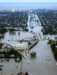
 According to a recently undertaken by the American Geophysical Union, the flood maps across America are dangerously outdated.
Science News reports on this story. The Union came to this decision at their annual fall meeting, looking at data from across the country. Despite U.S. Federal Emergency Management Agency estimates, the group says that the estimates for flood risk in different parts of the country do not reflect the actual risks involved with living in those areas.
While the latest federal estimates place about 13 million people in a “1-in-100-year” flood zone, the Union contests this. FEMA’s assessment mainly focused on larger bodies of water, they point out, rather than taking into account those that are smaller and might overflow due to heavy rains and the like.
Through a combination of different data points collected from the U.S. Geological Survey’s river gauge data, the National Oceanic and Atmospheric Administration, the Environmental Protection Agency, and several other groups, the Union predicts that around 40 million people live in the “1-in-100-year” flood zones, substantially more than FEMA’s prediction. The Environmental Research Letters publication is currently reviewing a paper based on these findings.
Additionally, the researchers predict that land development plans in the near future could see that number increase to 60 million people by 2050, with 75 million by 2100. However, University of Bristol geographer Oliver Wing notes that these predictions only account for areas that are currently noted as being at risk, with the true numbers having the potential to be significantly higher due to currently unplanned development and climate change. Climate change was noted as an exceptionally important risk, with the global rainfall trends shifting over the course of years and potentially putting many areas of the United States and the rest of the world at risk of flooding never thought possible before.


